Future Land Use Background Information
The future land use plan is a required component of the Comprehensive Plan. Through the future land use plan, the City will identify growth areas and specific land use categories to develop the vision for how areas of Auburn should grow over time. This is a proactive tool that allows the City to develop a strategy for which areas should see different types of growth.
The future land use plan establishes a vision for how land should be used in the future.
This includes:
- Identifying where different types of development are most appropriate
- What size and scale of future growth is appropriate in a certain area
- Vision for what the future of this area should look like
This page provides background information on future land use plan components and provides an opportunity for the community to identify what different areas of the City should look like in the future.
Background Documents
-
Future land use handoutPDF (2.02 MB)
This handout consolidates information found in the background information section of this website.
-
Growth area maps and rationalePDF (4.82 MB)
This file contains the Growth Area Map and Land Use Category Map, as well as additional information on growth areas. This information is summarized in the background information section on this website.
-
Growth Area MapPNG (998.06 KB)
This file contains the growth areas map, which shows high, moderate, and low growth areas.
-
Land Use Category MapPNG (893.34 KB)
This file contains the land use categories map, which shows identifies unique land use areas across Auburn.
Background information
Future land use is about setting a shared vision for how different parts of Auburn should grow or stay the same over time. It helps guide decisions about housing, businesses, roads, utilities, and conservation, but it does not change zoning today.
Use the tabs below to learn more about future land use, growth areas, and recent state legislation that impacts growth areas.
What is a Future Land Use Plan?
What does a future land use plan do?
A future land use plan:
- Guides long‑term growth and investment
- Reflects community values and priorities
- Informs future zoning and infrastructure decision
- Does not rezone property
- Does not approve specific developments
- Does not change property taxes directly
- Growth areas
- Land use categories
What are growth areas?
What are growth areas?
Growth areas are required components of the comprehensive plan. These areas outline where the highest amount of growth should be directed, where the least amount of growth should be directed, and where areas should transition from high to low density.
What are High Growth Areas?
High Growth Areas are parts of the city where Auburn plans for most new development, redevelopment, and investment over time. These areas are intended to accommodate housing, businesses, and services in ways that support a vibrant, efficient, and connected community.
What typically happens here?
- New housing and mixed use development
- Redevelopment of underused or vacant sites
- Improved streets, sidewalks, and infrastructure
- Access to jobs, services, and amenities
Why focus growth here?
Directing growth to specific areas helps:
- Support walkable, active neighborhoods
- Make efficient use of public infrastructure
- Reduce pressure on rural, natural, and low density areas
What are moderate growth areas?
Moderate Growth Areas are places that sit between high density areas and more rural areas. These areas may see some change over time, but at a slower pace than high-growth areas.
What typically happens here?
- Incremental growth, infill, or redevelopment
- A mix of housing types or small scale commercial uses
- Changes that step down in size, height, or intensity from high growth areas
- Reuse of existing buildings
Why are Moderate Growth Areas important?
They help:
- Create smooth connections between different parts of the city
- Balance new development and protection of rural areas
- Reduce abrupt changes in scale or use
- Provide flexibility as community needs evolve
What are Low Growth Areas?
Low Growth Areas are places where Auburn plans to see the least amount of development. These areas often include open space, agricultural and forestry activities, or environmentally sensitive lands.
What typically happens here?
- Minimal new development
- Preservation of natural resources and open space
- Protection of rural or low density form
- Continued use of existing homes, farms, or conservation lands
Why are Low Growth Areas important?
They help:
- Protect natural and environmental resources
- Preserve rural landscapes
- Reduce infrastructure costs
- Direct growth to areas better suited to change
What are land use categories?
Land use categories describe the different kinds of places that exist today or could exist in the future, based on how land is used, the types of buildings, and how people live, work, and get around in those areas.
Each land use category includes a mix of characteristics like:
- The types of homes (like single-family houses, apartments, or town homes)
- Whether there are businesses, shops, offices, or industry.
- How dense or spread out the buildings are.
- What transportation options exist (like sidewalks, roads, or transit)
- Whether there are parks, open spaces, or community facilities.
- Instead of focusing only on uses like "residential" or "commercial," different categories should describe the look and feel of an area, including the broad scale, design, and mix of uses.
Land use categories provide additional direction for how growth should happen in high, moderate, and low growth areas.
Recent legislative changes
Additional information
Additional information on recent legislative changes can be found using the links below:
- Southern Maine Planning and Development Commission: https://smpdc.org/leg
- State of Maine Legislation Guidance Document: https://www.maine.gov/moca/sites/maine.gov.moca/fi...
What is LD 997?
LD 997 requires municipalities to allow residential development in all commercial zones. Municipalities may limit the number of residential units in a commercial development and can limit ground floors of buildings in commercial zones to be restricted for commercial uses. Today, this includes areas in Auburn that are in the General Business and General Business II districts.
What is LD 1829?
LD 1829 is a statewide housing law that changes how much housing must be allowed on residential lots, particularly in high growth areas and areas served by public water and sewer. The law limits how restrictive local zoning can be when it comes to housing density.
The following requirements relate to growth areas.
These requirements establish the largest minimum lot size that can be required in different areas. Should water and sewer be expanded in the future, whether by the City or private developer, the density requirements would apply to future developments and infrastructure expansions.
In high growth areas with both water and sewer access:
- Minimum lot sizes can be no larger than 5,000 square feet (roughly 1/8 of an acre) for the first four units and no more than 5,000 square feet for each additional unit
In moderate growth or low growth areas with both water and sewer access
- Minimum lot sizes can be no larger than 5,000 square feet (roughly 1/8 of an acre) for the first two units and no more than 5,000 square feet for each additional unit
In any area without both water and sewer
- Minimum lot sizes can be no smaller than the State's Title 12 septic minimum, typically 20,000 square feet per lot (about 1/2 of an acre)
- Municipalities can require lot sizes larger than 20,000 square feet areas that do not have both water and sewer access
What does this look like?
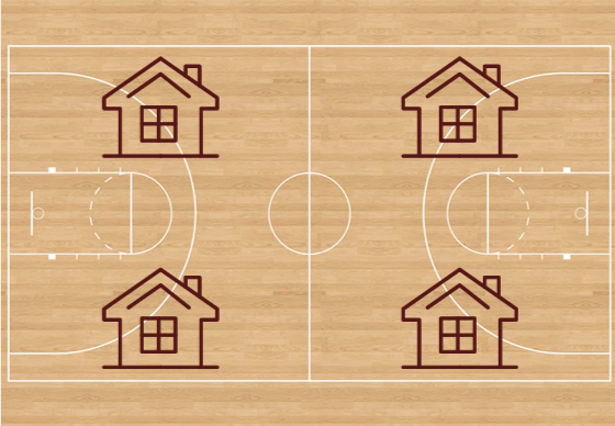
Lot size equivalent 5,000 square feet can be hard to conceptualize. This is roughly 0.11 of an acre. This is slightly smaller than one eighth of an acre (5,445 square feet), and slightly larger than a professional size basketball court (4,700 square feet).
High Growth Areas
On lots in high growth areas with access to BOTH water and sewer, this would look like four units on a lot that’s roughly the size of a professional basketball court.
State guidance notes that a lot owner with a 5,000 square foot lot in a high growth area with public water and public sewer may construct the following unit types: a quadplex; a triplex; a duplex and an accessory dwelling unit; a duplex and an accessory dwelling unit; a single-family dwelling unit; or a single-family dwelling unit and an accessory dwelling unit.
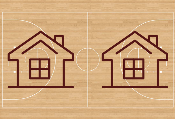
In areas outside of a high growth area, but with access to water and sewer, this would look like two units on a lot that’s roughly the size of a professional basketball court.
Two units on a basketball court could look different across lots: For example, state guidance notes that a lot owner with a 5,000 square foot lot with public water and public sewer (but outside a high growth area) may construct the following unit types: a duplex; a duplex and an accessory dwelling unit; a single-family dwelling unit; or a single-family dwelling unit and an accessory dwelling unit.
Areas without both water and sewer
Minimum lot sizes can be no smaller than Title 12 septic minimum, typically 20,000 square feet (or about ½ of an acre)
Municipalities can require lot sizes larger than 20,000 square feet in areas that do not have both water and sewer access
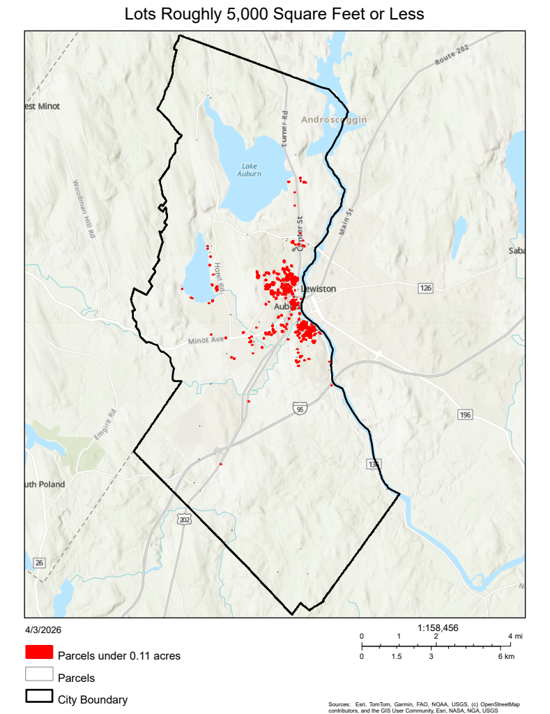
What does this look like in Auburn today?
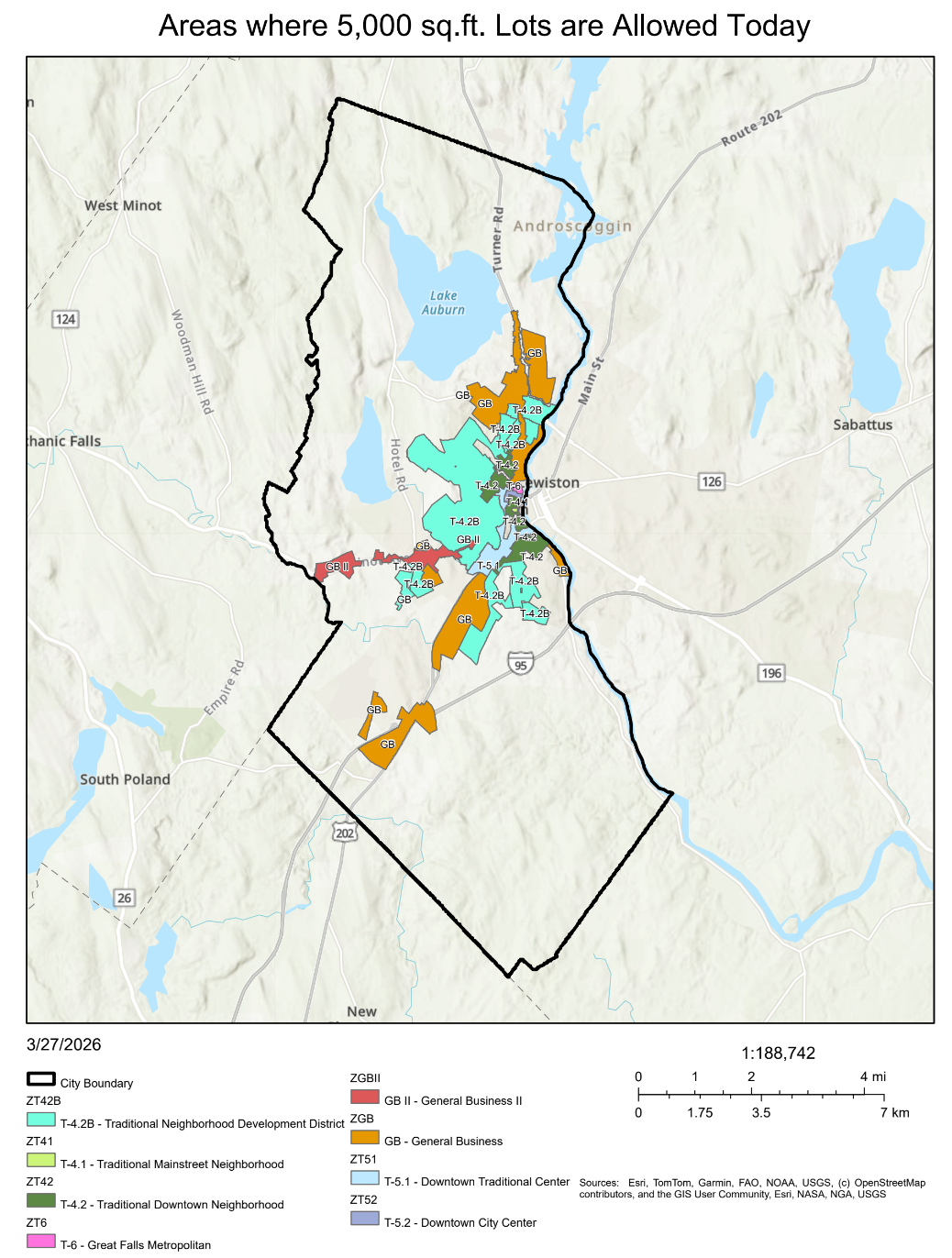
In Auburn, there are 851 lots that are roughly 5,000 square feet (0.11 acres or less) in size. These lots are largely concentrated in the dense, urban neighborhoods surrounding downtown. There are areas with sparce clusters of 5,000 square foot parcels around Taylor Pond, around Minot Avenue, and just outside of New Auburn. There are singular 5,000 square foot lots scattered throughout the City. These lots contain a variety of uses, including a variety of residential densities (single family through multi-family) and commercial uses.
Where is this density allowed today?
Currently, there are several areas in Auburn that allow for the level of density outlined in LD1829. These include all form-based code districts and the General Business (GB) district and GBII district.